We are deeply and firmly convinced of the fact that
the Siberian Railway is an indestructible monument of culture of the XIX-th century,
a manifestation of the Russian national grandeur, discharge of the moral duty of the
contemporaries in the face of coming generations; that it is one of the best pages in
the Modern Russian History, a step on the threshold of the XX-th century". ("Priroda
i Lyudi" (Nature and People) Magazine. Petersburg, 1890)
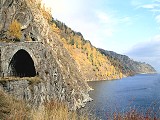
Formerly it was the most exotic part of the Trans-Siberian Railway. The sacred lake
with all its awesome beauty passed before the eyes of the passengers of the trains
going eastwards. On the one side, the rocks pile up unimaginably high. The lake shining
and sparkling is bound on the other side by dove-coloured mountains. The waves from the
lake "lick" the car-wheels.
|
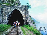
The quiet grandeur of the plain stone portal with its high quality masonry and
the way the arch joins the coastal slope, charms the visitor. It seems to have
been there for ages rather than only four quarters of a century. |
The construction of the Circumbaikal Railway as part of Trans-Siberian
Railway (the section from Port Baikal on the south-western shore of the lake) to Mysovaya Station
(on the south-eastern shore) took 4 years. Ancient crystal rocks:
granite, gneiss, gabbro, diabase, - possess enormous strength; the steep rocky shores precipitously go under
water, forcing to make excavations and niches in rocky cliffs, to construct arches and tunnels.
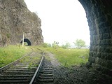
The railway is 84 km long. It includes not only russian engineering design of that time but also of the hard
work of Russian, Polish, Italian and English workers. The Circumbaikal Railway needed 200 bridges and 39
tunnels. Only within the section of 52 miles from Kultuk to Port Baikal there are 48 arches and tunnels.
Most of the tunnels are not very long. There are a few tunnels long enough so that passengers experience
total darkness. Polovynny Cape is cut through by the longest one (807 m). And how many bridges, supporting the
walls! It is no coincidence that this part is righteously regarded as the museum of Russian engineering thought,
and foreign tourists respectfully name it - "The Golden Buckle of the Great Siberian Trail".
More details:
The first exploration of a possible route for the first section of the Circum-Baikal, from Irkutsk to Lake Baikal, was carried out
in 1894. Initially the surveyors proposed to build a pontoon bridge and have the railway go down the right (east) bank of the Angara
River (the left bank was too built up); however, later this variant was found to be inexpedient, as the level of water in Angara was
subject to fluctuations, and during spring thaws crossing the river would have been difficult. Therefore the planners decided to
establish the railway from Irkutsk along the left bank.
The construction of the railway along Angara from Irkutsk to Cape Baranchik (Port Baikal) on Lake Baikal was carried out in 1896-1900,
costing a total of 3.47 million rubles. In the meantime, East of the lake the railway from Sretensk was completed up to Mysovaya on
the east shore of Lake Baikal. With the purpose of establishing a through railway connection, before the Circum-Baikal was finished,
it was decided to link the shores of the lake with a railway ferry. The trains were carried on special ice breaker-ferries "Baikal"
and "Angara". In the cold winter of 1903/04 when the ice breakers were not strong enough to break the ice, a railway line was laid
on the ice, and the cars were drawn by draft animals.
Meanwhile, the construction of another section of track, intended to fill the gap in the Transsiberian railroad, was carried out.
The routing of its eastern section, from Mysovaya to Kultuk (at the lake's southwestern tip), passing along the flat southern coast
of the lake, did not cause disputes. The greatest complexities were caused by the western section, meant to connect Irkutsk and
Kultuk. According to the results of the work of mountain engineering parties, on June 29, 1889 the committee on a construction of the
Siberian railway chose the third options from four initial proposals. From 1899 to 1900 final survey work was down, and the engineers
preferred to lay the line along the lake shore. Despite the difficult terrain along the shoreline, which consisted of a rocky ridge
with abrupt slopes, towering above the waters by 270 to 400 m, calculations showed this option to be the most economical. The final
decision on the line was made by the committee on the construction of the Siberian railway on June 22 1901. The cost of construction
of the given piece of road was 52.52 million rubles. The transportation engineer Boleslav Cavrimovich was appointed the construction
director.
Construction of the railway
The construction of the Circum-Baikal railway began in late 1899. Originally the efforts of the builders were concentrated on the
section from Mysovaya to Tankhoy. Beginning in 1901, the section from Tankhoy to Slyudyanka was laid. The construction of these
sections was carried out chiefly by the detainees and hard labourers of the Aleksandrovsky prison.
Workers began construction on the most complex section, from Slyudyanka to the Baikal station, only in the spring of 1902, with the
aim of finishing it by 1905. The original plan required the construction of 33 tunnels, at a cost of 5.3 million rubles, a retaining
wall for 3.7 million rubles, and viaducts for 1.6 million rubles. With regard to the possible negative impact caused by the lake
water, the minimum necessary height of the track route over the water of Baikal was calculated to be 5.33 m. Technical conditions
during the arrangement of the double-track sections fixed the bandwidth of the roads at 14 pairs of trains per day.
Owing to the lack of a flat shoreline all the materials (with the exception of stone mined at the site) were brought by water to the
site of construction (by barge during the summer, by animal-drawn carts in the winter). The complex terrain of the rocky shore
compelled the builders to lay the majority of the route in tunnels or on artificial shelves cut out of the rock; the sides of the
railway were strengthened with retaining walls. The workers, already suffering under the hot summers and harsh winters, were required
to carry out the majority of the construction by hand.
Every kilometer of the road required the expenditure of about one wagon of explosives. Earthwork was carried out in volume,
approximately equal to 400 wagons. Embankments amounted to 28.7% of the length of the road, cutting, to 71.3% (with a great deal
in rocky soil). The upper construction of the railroad ways had to be made heavier, using more powerful track and increasing the
number of ties. Because of the difficult terrain the minimum radius of the turns was reduced.
The onset of the Russo-Japanese War in 1904 caused an acceleration in railway construction. From 1901 to 1902 about 9 thousand
workers were employed on the railroads, while in 1903-1904 the number rose to 13.5. The main efforts were focused on the construction
of the railway line itself; therefore, the development work on stations and towns in the path of the line did not take place. Work
trains began to circulate on the railway on October 1 1904 and on October 29 1905 the line was brought into permanent operation.
The length of the railway in its final form from Baikal station to Mysovaya was 244 versts (260 km). The aggregate value of one
kilometer of the Circum-Baikal railway was about 130 thousand rubles (compared to 93 thousand rubles on the other legs of the
Trans-Siberian Railway).
Active operation
When the Circum-Baikal railway was put into operation, the Trans-Siberian railway around Baikal was linked, and began to be used to
transport goods and passengers. The Circum-Baikal was called the "golden buckle on the steel belt of Russia".
Initially, only one track was built; from 1911 to 1914 the construction of a second track was undertaken, which increased capacity
of the Circum-Baikal to 48 pairs of trains a day. In this stage of the construction of bridges and other engineering structures
reinforced concrete was introduced as a new material. As part of these works, considerable attention was paid to the construction
of stations and station towns. On the section from Baikal to Slyudyanka alone ten stopping points were set up. Measures have been
taken to improve traffic safety and protect against landslides.
During the revolutionary events of 1917 and the subsequent civil war the Circum-Baikal was the scene of intense fighting, as
evidenced by the mass graves of victims of those events. The Red Army, retreating from the Czechoslovak Legions, blew up the
Kirkidaysky tunnel (� 39, past Slyudyankoy on the way to Mysovaya) on July 23, 1918. The tunnel was later restored, but there
was no movement on the line for almost 20 days. In the 1930s, 40s, and 50s, the villages were actively developed, and homes,
barracks for the troops, and power plants were built.
Decline
In 1940, exploration work was initiated to strengthen the track and ensure the safety of traffic on the Circum-Baikal Railway.
Owing to the start of the Second World War, the work was completed only by 1947. The group in charge of development came to an
unexpected conclusion and citing the enormous cost, proposed not to carry out any work on the railroad along Lake Baikal. Instead
they proposed to transform the single track from Irkutsk to Slyudyanka across the mountains into an electric double track.
From 1947 to 1949 an electric transfer railway from Irkutsk to Bolshoy Lug to Slyudyanka was built, noticeably shortening the
distance compared with the Circum-Baikal branch line. The main route of the Trans-Siberian Railway was therefore transferred to
the new section.
In 1950, construction on the Irkutsk Hydroelectric Power Station plant was begun. In connection with this, the part of the
Circum-Baikal railroad from Irkutsk to the town of Baikal that passed along the Angara River was disassembled and in 1956
flooded during the filling of the Irkutsk reservoir (only remnants of dams remained on the shore of the Angara near the town
of Baikal). In the end, a modern, "dead-end" route of the Circum-Baikal (from Slyudyanka-2 to Kultuk to Marituy to Baikal).
The railway lost its strategic importance, the number of trains on the road dropped sharply, and security was withdrawn from
the tunnels and bridges.
Because it was no longer needed, the second track of the Circum-Baikal was disassembled. In the early 1980s, some even proposed
the closure of the line, or that an automobile highway be constructed in its place. The villages along the road gradually
deteriorated, and people began to abandon their houses. Virtually the only means of communication with the heartland for the
residents of these places was the rarely running diesel locomotive, and later a locomotive connected Slyudyanka, Kultuk, and
Baikal (Port Baikal is linked to the village of Listvyanka on the opposite shore of the Angara by an automobile ferry).
Landslides and other natural phenomena on the Circum-Baikal
The greatest challenge for the Circum-Baikal Railway was and still is frequent landslides and mud flows. Even at the time of
surveying, engineers noted a strong weathering of the rock layers and a great amount of scree. The demolition of the hillside and
the steep slopes during the construction of the road provoked a catastrophic intensification of geodynamic processes. Severe
landslides occurred during the construction of roads, in particular by tunnel 5 in April 1904 a collapse of about 3000 m3 occurred,
and a month before the end of the construction a collapse occurred in tunnel 9 of about 1000 m3, damaging the masonry of the tunnel.
The results of further studies of the rocks along the road showed that they were not as robust as the initial surveys had expected.
Moreover, the work associated with the construction of the railroad (particularly the work using explosives) led to the formation
of numerous cracks in the rocks below. Having recognized this danger, the authorities agreed on the construction of retaining walls,
the stripping of the hillside, and other measures. In some places dangerous sections were rerouted with new tunnels. Nevertheless,
in spite of the work to prevent natural hazards, landslides were a frequent and dangerous phenomenon on the Circum-Baikal, often
leading to crashes and interruptions in roadwork. For example:
- In early April 1913 a 4000 m3 landslide occurred on the Irkutsk side at tunnel 16. As a result, the movement of trains was suspended
for ten days.
- In April 1929, owing to an earthquake there was a shift in the rock mass at the 143 km mark, which then collapsed from a height of 200m.
The rocks broke the retaining wall and damaged both tracks (some pieces were as much as 30 m3 in size; they were removed through
detonation). The delay in traffic as a result of the collapse was 12 hours.
- In 1937, a piece of rock about 4 m in diameter fell on a train car, broke through the roof and the floor, and caused a train crash.
- In 1936, the Marituiskaya section was built for safety purposes. It was one of the most complicated sections of railway in the country.
- In 1939 on the Western Siberian Railway the Travelling Machine Station was built, which was carried out by anti-landslide
workers (including even rock-climbers). The levelling and clearing of dangerous slopes has continued until this day.
- In May 1941 at the 87 km mark of the railway, an 8 m3 block, having broken off from height of 30 meters, overturned a moving
train together with a steam locomotive into the lake. This boulder, which has become a popular sight, still today holds down
some parts of the car.
- On September 27, 1948 at the 104 mark, a slope collapsed (100 m in length and 35 meters in height), with a general volume of
about 20 thousand m3. As a result, circulation stopped for four days.
- In 1982, a collapse of 900 m3 occurred, stopping circulation for a week.
- In 1991, a collapse of about 700 m3 closed off the entrance to a tunnel at the 140 mark.
Among other natural phenomena, mudflows and floods had a negative influence on the Circum-Baikal traffic safety. The greatest
activity in this respect occurred on the river Slyudyanka, which runs into Baikal near station 1. On July 29, 1934 a mudflow
on this river had catastrophic consequences, carrying off in its wake several apartment houses and covering the station with
a thick layer of silt and sand. In 1960 the mudflow on Slyudyanka again washed away train tracks and destroyed a series of
dams. Powerful downpours in 1971 caused the strongest floods, which led to the destruction of several bridges and tunnel
entrances, as well as a the foundations of a track on the Circum-Baikal (the interruption of traffic lasted almost a week).
Another unusual natural phenomenon occurs on the south side of Baikal: the deposition of ice sometimes causes a several-meter
heap of ice blocks on the coast, covering the railways with ice.
In 16 years alone, from 1932 to 1947, 721 collapses occurred, of which 502 were without consequences for the railway, 201
closed off a single stage and disturbed the top structure of the railway, and 18 caused train-wrecks and the destruction of
the embankment. According to the data of the Eastern Siberian Engineering Service, between 1930 for 1984 about 1200 collapses
and mud-flows were recorded. Besides this, about 500 cases of falling of separate stones caused damage to the railway and a
rolling-stock. Engineers described trips on the Circum-Baikal as exciting but dangerous.
Current condition
In the present day the Circum-Baikal Railway is the name of an 89-km-long branch covering the route Slyudyanka-2-Kultuk-Maritui-Baikal.
Four stations are currently in operation: Kultuk, Maritui, Ulanovo, and Baikal, with one section of double track at 137 km. The
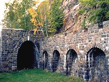
Circum-Baikal contains thirty-eight tunnels for a total length of 9063 m (the longest of them, a tunnel through cape Polovinnyj,
is 777.5 m long). There are also 15 stone galleries with a total length of 295 m and 3 ferro-concrete galleries with apertures,
248 bridges and viaducts, and 268 retaining walls. The Circum-Baikal has no equal in Russia as to the richness of engineering
constructions. The tunnels and stone galleries of the Circum-Baikal are unique in that they were constructed atypically and have
not been reconstructed since, conserving the initial plan of architects and engineers of the beginning of the century.
The kilometers on the modern Circum-Baikal are traditionally measured from the Irkutsk sorting station, which until 1934 was the
administrative border between the Tomsk railway and the railway after Baikal. The Baikal station is thus located 72 km from this
point of readout, and the Slyudyanka-2 station, at 161 km.
In the 1980s and 1990s, measures were begun to reconstruct and strengthen the railway. Currently, normally one train a day
(a diesel locomotive and two cars) runs on the railway. The duration of the trip from Slyudyanka to Port Baikal station is 6
hours. The inhabitants of the roadside settlements call the train a 'Peredacha', or "transfer", reflecting the value of this transport
for the supply of necessary articles such as bread, salt, matches, vodka, and tobacco. Another name given to the train is 'motanya'
(so called because the train rushes or 'Motaetsya' between stations).
With the decision of the Irkutsk regional council on December 21, 1982, the section of the Circum-Baikal from Baikal station to
Kultuk station was declared an architectural and scenic reserve (it is now part of the Baikal National Park) and put under the
state protection. Beginning in the early 1980s the tourist potential of the Circum-Baikal Railway has started to come into its
own (the stations, however, were used to a limited degree since the railroad's inception as areas for dachas and recreation).
A series of tourist areas are in operation ("Taiga" at 134 km, "Sensation" at 102 km, "Coniferous" at 98 km, "Retro" and the
"Silver Key" at 80 km.
Along with actual railway sights, tourists on the Circum-Baikal route are attracted by the numerous nature sanctuaries, including
the rocky formations such as "Belaya viemka". In the settlements along the Circum-Baikal, especially in Maritui, a number of early
twentieth-century in the modernist style are preserved.
Sources used: BaikalWebWorld, Wikipedia
Travel to Circumbaikal Railway |
|
|